President Resolves Strait of Hormuz Crisis
The Rutabaga
Word Count 880 Reading time 3.5 minutes
Vol. CXII, No. 14 Wednesday, April 1, 2026
Happy April Fool’s Day
$4.00 (or free, if you find it on the ground)
GLOBAL AFFAIRS / CARTOGRAPHY
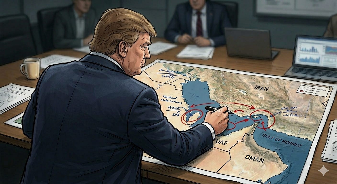
President Resolves Strait of Hormuz Crisis with Stroke of Blue Sharpie
By CHIP VANDERMEER, Senior Diplomatic Correspondent | The Rutabaga | Washington, D.C.
IranQeshm Island(Iran), UAEMusandamPeninsula (Oman)Oman, Gulf of Oman, PersianGulf , Strait ofHormuz.
Both colored in — Sharpie, Blue, Medium Point
Official Map — Strait of Trump, formerly Strait of Hormuz
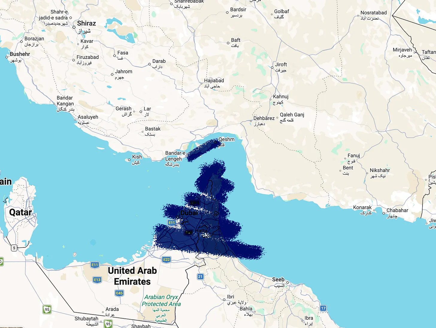
WASHINGTON — In what administration officials are calling “a historic act of geographical problem-solving,” President Donald Trump announced Friday that he has resolved the months-long crisis blocking commercial shipping through the Strait of Hormuz by coloring in the Musandam Peninsula of Oman and Iran’s Qeshm Island on an official map using a medium-point blue Sharpie marker, thereby eliminating them.
The announcement, delivered at a Cabinet meeting open to cameras for approximately eleven minutes, featured the President holding aloft a laminated nautical chart of the Persian Gulf on which both landmasses had been filled in with thick blue ink, rendering them the same color as the surrounding water. “They’re gone now,” Trump told reporters, gesturing at the blue shapes. “Gone. Beautiful open water. All the way through.”
“Nobody else could have done this,” the President told reporters. “The generals couldn’t do it. The admirals couldn’t do it. You know why? Because they don’t have the brain for it. They think in troops, in ships, in whatnot. I think in solutions. Only someone with a brain like mine could accomplish that without ground troops.”
“They’re gone now. Gone. Beautiful open water. All the way through.”
The move drew immediate comparisons to the President’s celebrated 2019 intervention in Hurricane Dorian’s projected path, in which a cone-of-uncertainty chart was similarly modified with a black Sharpie to include the state of Alabama. That maneuver, widely praised in certain corners of the internet, is now taught in select meteorology programs as a cautionary example. Friday’s solution is considered a significant technical evolution: where 2019 involved merely extending a line, 2026 involves filling in solid landmasses — a distinction the President called “much harder, much more precise, like a surgeon.”
Asked whether Oman and Iran were aware that their respective territories had been colored in, Press Secretary Karoline Leavitt said the relevant governments had been “notified through appropriate channels” and that their reactions were “not the point.”
“The Musandam Peninsula is a sovereign exclave of Oman. Qeshm is the largest island in the Persian Gulf and home to approximately 140,000 people. Coloring them blue on a map does not remove them. They remain, physically, where they have always been. I cannot stress this enough.”
— Dr. Renata Söderström, Senior Fellow, Center for Maritime Geography, Stockholm. Speaking strictly on background and from a different country.
Treasury Secretary Scott Bessent confirmed that global oil markets had “largely stabilized” following the announcement, attributing the recovery to “investor confidence in the President’s Sharpie” and noting that tanker insurance premiums had dropped 12 percent within an hour of the map being shown on television. Analysts at JPMorgan Chase issued a note Friday afternoon stating only: “We are monitoring the situation.”
Iran’s foreign ministry, reached for comment, said it had “no response at this time to the map” and requested that journalists “please stop calling.” A spokesperson for the Qeshm Island Free Zone Authority noted that the island’s 140,000 residents “continue to exist” and asked whether the United States had “perhaps confused a map for the actual place.” The State Department did not respond.
Oman’s government issued a brief statement confirming that the Musandam Peninsula “remains part of Oman, remains above sea level, and is not blue.” A subsequent statement added: “We would also like the Sharpie returned.”
“In forty-one years of hydrological research I have never been asked whether coloring a peninsula blue on a laminated surface removes it from the physical world. I want that on the record. I am putting that on the record right now. The answer is no. The answer is emphatically, categorically, with no caveats whatsoever, no.”
— Prof. Gerald Okafor, Dept. of Hydrological Sciences, MIT. Via email. Sent entirely unprompted at 4:47 p.m.
The White House confirmed late Friday that the President has signed an executive order renaming the Strait of Hormuz the Strait of Trump, effective immediately, and that new laminated maps reflecting the blue landmasses would be distributed to “all the ships” by the end of the quarter. A second executive order is reportedly in preparation designating the now-blue Musandam Peninsula and Qeshm Island as “federal water” under U.S. jurisdiction, though legal counsel has reportedly asked for “a few days” and has not been seen since.
Asked whether he planned to pursue further diplomatic or military options in the region, Trump said he did not rule it out, but felt the Sharpie approach had “really handled it” and that he expected a Nobel Prize “at minimum — probably two.”
The Nobel Committee in Oslo has not responded to a request for comment. They have, however, changed their phone number.
Shipping resumed through the strait Saturday morning. The Musandam Peninsula and Qeshm Island were still there.
The Rutabaga is a publication of satirical record and holds no responsibility for the navigational decisions of tanker captains who consult our maps.
No actual straits were widened in the production of this article. Sharpie® is a registered trademark of Newell Brands. The Rutabaga has no affiliation with Newell Brands, though we remain open to sponsorship.
FTS
Join us on our podcast Specifically for Seniors, where satire meets substance and storytelling sparks civic engagement. Each episode dives into topics like authoritarianism, political spectacle, environmental justice, humor, history and even fly fishing and more—layered with metaphor, wit, and historical insight. We feature compelling guest interviews that challenge, inspire, and empower, especially for senior audiences and civic storytellers. Listen to the audio on all major podcast platforms, watch full video episodes on YouTube, or explore more at our website.
Let’s keep the conversation sharp, smart, and unapologetically bold